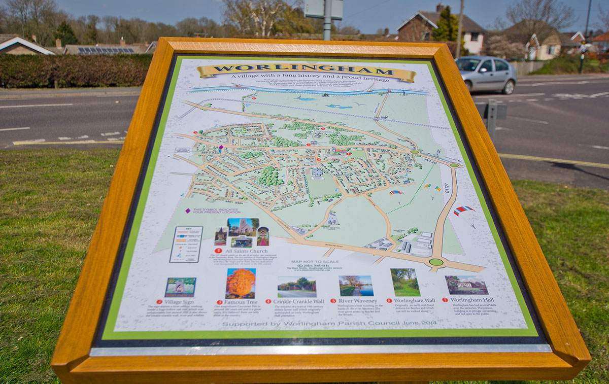
Worlingham Village
Worlingham is a village and civil parish in the East Suffolk (formerly Waveney) district of Suffolk. It is approximately 1 mile east of the market town of Beccles and approximately 8 miles west of Lowestoft. Nearest city is Norwich which is 25 miles in a north west direction, albeit this is in Norfolk.
Worlingham is bounded to the North by the River Waveney and the adjacent low-lying marsh land lies within the Broads Authority.
The greater part of Worlingham is concentrated around the main road (Lowestoft Road) which runs from Beccles to Lowestoft. Prior to the building of the A146 Beccles Bypass in the early 1980’s this road was the main route between Lowestoft and Norwich.
Housing to the south of the Lowestoft Road has become contiguous in nature since the 1960’s and as the community has grown.
Towards the south boundary lies the Ellough Industrial Estate. The industrial estate is mainly situated on a former WW2 airfield site which was built towards the end of the war and which never became fully operational. Rumour has it that following completion of the runways it was found that enemy ships off the coast could potentially observe the runway via their telescopes. After the war the airfield was used as a base for search and rescue aircraft and later in the 1960’s, 70’s and 80’s was a base for helicopters serving the North Sea oil rigs. Part of the airfield is now used for light aircraft and parachute jumps.
A recent bypass completed in 2018 towards the south of the village and incorporating the industrial area has eased traffic coming through Worlingham and Beccles. This together with the A146 Beccles/Worlingham bypass built in the early 1980’s has reduced heavy traffic considerably.
The current number of residents in the village is just under 4000 occupying approximately 1500 properties.
Amenities in the village include a “One Stop” convenience store (which also incorporates a Post Office), a hairdressing/beauty salon, fish and chip takeaway and a newsagent. A pharmacy also exists, the building having once been the village pub called The Colville Arms which closed in the early 2000’s. Unfortunately no public houses currently exist in the village.
There is also a car sales site to the east of the village, the site once being the local blacksmith’s.
There is one school in the village and more details regarding this can be seen later in this document.
Early maps show only a handful of residential properties in the village and it was not until after the First World War that the village expanded with single houses and small developments. The first housing “estate” in the village would have been around the Highland Drive area, these being built in the late 1950’s and early 1960’s. In the late 1960’s / 70’s developments around the Garden Lane area sprang up and then major developments off Cedar Drive, Bluebell Way and Pepys Avenue (Werel’s Loke) came along in the 80’s, 90’s and 2000’s.
Historical records relating to Worlingham go back to the time of William the Conqueror via The Domesday Book of 1086, albeit the village was recorded as Werlingham at the time. At some stage the village was later split and thus became Great Worlingham and Little Worlingham / Worlingham Parva.
In 1281 Worlingham was recorded in the Patent Rolls, these being administrative records held by the English Chancery. Within these records there is mention of land named “Coplestone” and this name was used more recently to name a new residential road in the village ie. Copplestone Close.
Some influential families and figures have lived in the village throughout the 17th, 18th and 19th centuries. Sir Thomas Gooch was born in the village. He studied at Cambridge and received a doctorate in 1711 before becoming Vice Chancellor of the University of Cambridge in 1717. He later became a priest and subsequently became chaplain to Queen Anne before becoming Bishop of Bristol in 1737, Bishop of Norwich in 1738 and Bishop of Ely in 1747.
The Sparrow family were another influential family that resided at Worlingham Hall. Mary, the only daughter of Robert Sparrow, married the Right Honourable Archibald Acheson, Earl of Gosford, in 1835. The Earl was created a Peer of the UK by the title of Baron Worlingham of Beccles.
During excavations for the Werel’s Loke housing estate in the 2000’s (now Pepys Avenue/ Copplestone Close etc) various archaeological finds were found dating back to Bronze Age, Medieval and Saxon times.

Worlingham Hall
(Picture courtesy of ancestryimages.com)
Worlingham Hall, the seat of Lord Acheson, Earl of Gosford, was built by John Felton in the late 1600’s albeit it was enlarged and remodelled in the 1800’s by Francis Sandys on behalf of the then owner, Robert Sparrow. (The Sparrow family also owned a “summer residence” in Lowestoft which later became Sparrow’s Nest, Lowestoft’s first public open space). At this time the hall and estate extended to over 2800 acres. Over the years the hall changed hands a number of times and parts of the estate were broken up. The hall itself fell into a state of disrepair over the years until 1962 when it was purchased by Viscount Colville QC. At this time the estate only extended to 20 acres. Viscount Colville was a British Judge and Politician and was one of the 92 hereditary peers elected to remain in the House of Lords after the House of Lords Act 1999. He undertook extensive renovations over a number of years. The writer, albeit a young boy at the time, was acquainted with “Lord Colville” (as we called him) and regularly attended village events at the Hall including the annual village fete and annual “Halloween” children’s party.
In recent years the hall has been further improved and is now an 11 bedroom holiday location commanding a weekly rental in excess of £5000. In 2019 the hall was on the market for £5.5million. (Picture courtesy of Wikipedia)


Churches
(Picture courtesy of Wikipedia)
The village is currently served by one church, this being All Saints, situated along the Lowestoft Road, however, in previous times there were in fact two churches – All Saints serving Great Worlingham and St Peter’s serving Worlingham Parva.
It is believed that St Peter’s was no longer used after 1492 when the two parishes consolidated and unfortunately little is known about St Peter’s albeit during excavations for the A146 Worlingham / Beccles bypass in 1980 the foundations were found. It was a small early Saxon church with an apsidal chancel (semi circular recess) and round tower. A total of 23 skeleton remains were analysed and re-interned in 1981 at All Saints Church. A headstone exists close to the north wall of the cemetery in the new section of the church yard.
(Pictures courtesy of fisk-history.co.uk & roundtowers.org.uk)
All Saints was built during the 1300’s and extensive renovations and extensions were made during Victorian times. It would originally have had a thatched roof but is now tiled. Records of serving Rectors go back to 1371 and registers began in 1538. Although Worlingham is no longer served by its own resident Rector / Vicar regular weekly services continue via the Beccles Ministry team.
(Picture courtesy of churchofengland.org)
Village Schools
Early records show that a small day school existed for 10 pupils in 1818 however the first purpose built school in the village was the Worlingham National Church of England School which first opened in 1845 and was later enlarged in 1910. The school was closed and decommissioned in 1966 as a larger, purpose built primary school was built in Rectory Lane. The original school was demolished in 1980 as part of the A146 Worlingham / Beccles bypass development and would have stood where the current roundabout with Marsh Lane stands.
A Miss Janet Hadenham was a well known Headmistress of the original school for over 46 years and a residential road within Worlingham is named after her.
At the time of the move to the Rectory Lane site the headmaster was Phillip Wills and he also remained in the post for a number of years. He was also a very well respected organist and Choir Master at All Saints Church until the 1990’s.
In 1971 a brand new “Middle” school was opened in Garden Lane which accommodated over 300 children between the ages of 9 and 13. As well as housing village children it also bussed in children from outlying villages such as Ringsfield, Sotterley, Shadingfield, Brampton, North Cove and Barnby.
In 2013, following County Council educational changes, the Middle school in Garden Lane became the Primary School and the original school in Rectory Lane was permanently closed. It has subsequently been demolished to make way for a new community centre.
The site of the current Primary School in Garden Lane is believed to have been on the site of a former horse racing practice track and stabling, perhaps belonging to Worlingham Hall and may explain the names of nearby residential roads ie, The Ridings, The Bridles, Paddocks Green and Fairmile Close.
Church / Village Hall
Unfortunately Worlingham has never had a “village hall” as such but for many years villagers made use of the Church Hall in Rectory Lane. Little information exists in relation to its history but the writer estimates it was possibly built during the 1920/30 ’s. The hall was very well used by various organisations including the Women’s Institute, Parish Council, local dramatic groups, choir practices etc. The writer attended a weekly Youth Club during the 1970’s which was organised by Mr & Mrs Harvey and proved very popular. Unfortunately due to Health & Safety issues the hall was closed in 2005 and the village has unfortunately been without a designated meeting place ever since albeit the local school has been used for most events.
Building of a new community centre on the site of the original primary school in Rectory Lane is currently in the final planning stages and building work should start in 2022.
Serpentine Wall
Known locally as “the Crinkle Crankle Wall”, this is a unique man made physical feature within Worlingham and is situated in Garden Lane at the junction of Paddocks Green / The Ridings and The Bridles. These brick walls feature heavily in Suffolk and were often built to protect fruit crops.
The area around Garden Lane, Paddocks Green and Pine Tree Close was previously a market garden and before that possibly the main vegetable / fruit garden for Worlingham Hall so the positioning of this wall speaks for itself.
Worlingham Wall
Another lesser known Worlingham feature is a 1.6km earthwork bank known as the Worlingham Wall. It is believed to have been constructed in medieval times to act as a flood defence on marsh land to the north of the village close to the River Waveney. The bank flanks a central drainage ditch, probably on the lines of a natural creek, and became a natural physical border between Beccles and Worlingham.
(Picture courtesy of Roger Jones / geograph.org.uk)
Village Sign
The original village sign was funded by Worlingham Women’s Institute in the 1970’s and later replaced with a similar design in the 2000’s (pictured at the heading of this document). The sign depicts a cobbler working from inside a large hollow oak tree. This tree is rumoured to have been in the village and was over 500 years old. It measured 27 feet in circumference at a height of one foot from the ground. The village cobbler worked from this tree for a number of years. The sign also features the “Crinkle Crankle” wall.
Original Village Sign (Courtesy of Peggy Cannell / picturesofengland.com)
In more recent years the village sign has been replicated on two new village entrance signs which have been made using wood from a very mature, and possibly the oldest of its kind in the UK, Caucasian Elm in Park Drive that underwent substantial “surgery” to make safe. This tree would have lined the original entrance drive to Worlingham Hall.
Caucasian Elm in Park Drive (Courtesy of M Cannell / bbc.co.uk)
One of two new village gateway signs
(Courtesy of Wendy Summerfield)
Disclaimer
This brief historical history of the village of Worlingham has been put together by the writer via research on the internet and his own knowledge having lived in and around the village for the past 45 years. The writer takes no responsibility for the information supplied and welcomes any corrections. The writer can be contacted at stuholman42@btinternet.com.

